HyperAI
Command Palette
Search for a command to run...
RoadTracer Road Dataset
Date
4 years ago
Size
369.56 MB
Publish URL
Paper URL
License
Other
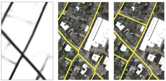
The RoadTracer dataset is a dataset for extracting road networks from aerial images. It includes a large image library (high-resolution satellite images and ground truth road network maps) covering an area of about 24 square kilometers around the city centers of forty cities in six countries (satellite images are from Google with a resolution of 60 cm/pixel, and road network images are from OSM). The dataset includes:
- A training set of 25 cities and a test set of 15 other cities
RoadTracer.torrent
Seeding 2Downloading 0Completed 760Total Downloads 890
This dataset is contributed by community users and is intended for educational and informational purposes only. If any content involves copyright infringement, please contact us at support@hyper.ai for prompt review and removal.
Build AI with AI
From idea to launch — accelerate your AI development with free AI co-coding, out-of-the-box environment and best price of GPUs.
AI Co-coding
Ready-to-use GPUs
Best Pricing
HyperAI Newsletters
Subscribe to our latest updates
We will deliver the latest updates of the week to your inbox at nine o'clock every Monday morning
Powered by MailChimp