HyperAI
Command Palette
Search for a command to run...
RIT-18 Remote Sensing Image Semantic Segmentation Dataset
Date
3 years ago
Publish URL
Paper URL
License
Other
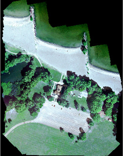
RIT-18 is a dataset for semantic segmentation of remote sensing images. The dataset was collected by a Tetracam Micro-MCA6 multispectral imaging sensor mounted on a DJI-1000 octorotor. The characteristics of this dataset include
- Ultra-high-resolution multispectral imagery from drones
- Six spectral VNIR bands
- Contains a severely imbalanced class distribution, involving 18 object classes (plus background).
This dataset is contributed by community users and is intended for educational and informational purposes only. If any content involves copyright infringement, please contact us at support@hyper.ai for prompt review and removal.
Build AI with AI
From idea to launch — accelerate your AI development with free AI co-coding, out-of-the-box environment and best price of GPUs.
AI Co-coding
Ready-to-use GPUs
Best Pricing
HyperAI Newsletters
Subscribe to our latest updates
We will deliver the latest updates of the week to your inbox at nine o'clock every Monday morning
Powered by MailChimp