Command Palette
Search for a command to run...
OpenSatMap high-resolution Satellite Dataset
Date
Size
Publish URL
Paper URL
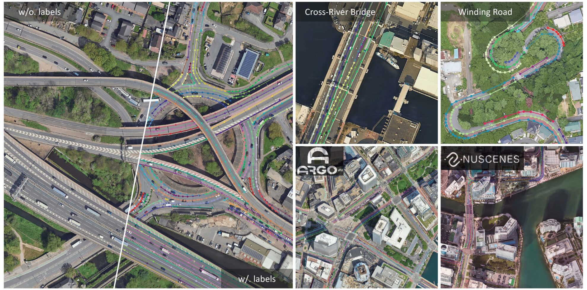
OpenSatMap is a high-resolution satellite dataset designed for large-scale map construction. The dataset was jointly developed by the Institute of Automation, Chinese Academy of Sciences (CASIA), the Artificial Intelligence and Robotics Research Center, Hong Kong Institute of Information Systems, Chinese Academy of Sciences, and the University of Chinese Academy of Sciences (UCAS). ,Tencent Maps and Beijing University of Posts and Telecommunications released the paper in 2024.OpenSatMap: A Fine-grained High-resolution Satellite Dataset for Large-scale Map Construction", has been accepted by NeurIPS 2024.
It features fine-grained instance-level annotations and high-resolution images, which have a resolution of 20 levels, the highest among existing satellite datasets. The scale of this dataset is quite large, containing 3,787 high-resolution satellite images, covering a variety of geographical locations, and is consistent with popular driving datasets, which is of great significance for the development of autonomous driving technology.
The diversity of the dataset is reflected in its wide geographical coverage, which includes images of not only multiple cities in China, but also more than 50 cities and 18 countries around the world. These images are collected from Google Maps with resolution levels 19 and 20, corresponding to 0.3 meters/pixel and 0.15 meters/pixel, respectively. OpenSatMap19 and OpenSatMap20 represent these two different resolution levels.
In terms of data representation, OpenSatMap uses vectorized polygon lines to represent line instances, and divides all lines into three categories: curb lines, lane lines, and virtual lines. For each line instance, the dataset provides 8 detailed attributes, including color, line type, number of lines, function, bidirectionality, boundary, shadow, and clarity, which are essential for understanding and using the dataset.
In addition, OpenSatMap introduced 2 tasks to promote research on instance-level line detection from satellite imagery and satellite-enhanced online map construction for autonomous driving.
Build AI with AI
From idea to launch — accelerate your AI development with free AI co-coding, out-of-the-box environment and best price of GPUs.